
Penguins!
Last fall when we were up in the San Juan Islands with Rick's family, we had talked with Rick's sister Shannon and her husband Chris about going to Southern Utah for a few days to take pictures. We had made plans in January to leave on March 31, and now it was time for the trip!
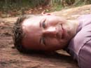
The 5am alarm seemed awfully early, but we knew it would be worth it! We packed up the car and headed to the airport where we were pleasantly surprised to find out that our upgrade to first class had gone through, bonus! The flight to Las Vegas was only about an hour and twenty minutes, which went by very quickly. As we were landing Rick made a comment about the penguins at the Flamingo Hotel, and how it was too bad we wouldn't get to see them. We picked up the rental car and realized we had just over an hour before Shannon and Chris' flight arrived, just enough time to make a run over to the strip to see the penguins! Rick was very excited!
The penguins all seemed like they had been out too late the night before, they were moving around a bit slowly, but they were still very cute. We spent about 15 minutes watching them, then dashed back to the airport for Shannon and Chris. We made a quick stop at a grocery store to get a cooler and supplies, then had lunch and hit the road, heading North towards Utah.
We made good time (75-mph speed limits help!) and, after a few miles in Arizona, were soon crossing into Utah. Once we got to St. George, Shannon suggested a detour to the North to see a cool dam. She had done wilderness guide work in the area a number of years before, and was a wealth of knowledge about where to go. From the Gunlock Reservoir dam we headed North and then turned East through Cedar City where we started to climb into the mountains.
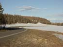
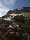
Cedar Break was an amazing red hillside where we stopped to take pictures. As we climbed higher up, the temperature dropped steadily, then we started to see quite a bit of snow at the sides of the road. Once we went over the pass and started to descend, the temperature went back up again. As we turned North towards Panguitch we found our hotel, the Wild West Hotel. It was laid out like an old west town, and was supposed to be set up for filming your own western movies. Unfortunately, it was too early in the season for any of that to be going, so we didn't get to break any fake bottles over our heads (sorry Jason!). Being early in the season also accounted for us being the only guests that night.
For dinner we were told that the best thing around was the Conoco Truck Stop in Panguitch. We went into town and looked around a bit, and it did look like the best place (mainly because there weren't many choices!). It's lots of fun eating just ten feet from the aisles of junk food in the mini-mart. Well, this is rural Utah you know. Chris' hot turkey sandwich turned out to be an open faced gravy covered heart attack on a plate, yum! After dinner we headed back to the hotel, looked at pictures for a while, then went to bed.
Thursday, April 1
We had decided to leave to hotel at 7am to get breakfast, once again back at the truck stop. It was actually pretty tasty, and it was convenient to be able to pick up some water and ice on our way out of the restaurant. We headed South, then East towards Bryce Canyon. Along the road we first encountered Red Canyon, which gave us a taste of what was to come.
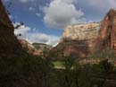
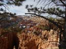
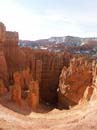
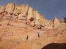
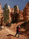
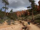
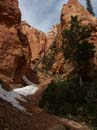
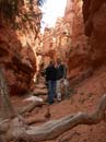
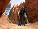
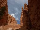
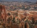
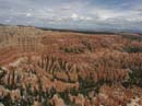
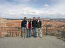
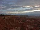
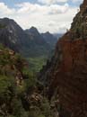
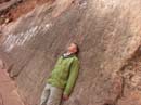
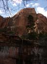
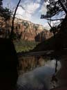
Once inside the park we headed to Sunset Point. We pulled out the cameras and supplies and embarked on the Navajo Trail down into the canyon. It was a 1.3 mile trail, just right for a couple of hours of picture taking. At a fork in the trail we decided to head down through a narrow canyon where the trail made several dozen switch-backs before reaching the valley floor. Then we walked along a dry river bed for a while. All along the way the scenery was absolutely amazing. The vivid red of the rocks, the deep green of the trees and the dark blue/gray of the sky. We reached a bend at the bottom of the trail and started back upwards along the return portion of the loop. The scenery continued to amaze us, pretty much all the way back up to the top. Near the top we could once again see the expanse of the main canyon, with all of it's tall spires (called hoodoos) stretching across the horizon.
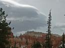
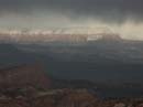
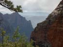
Back in the car we decided to drive the 20 miles or so to the end of the park road, then drive back to the Bryce Canyon Lodge to have lunch and check-in to our rooms for the night. The drive was very spectacular, with amazing scenery and a storm front moving in from the distance. The elevation climbed from 8300 feet to 9100 feet, and the temperature dropped as we went. After some final pictures, we turned around and headed back for lunch.
It was the first day of the season for the lodge, so they were still figuring things out at lunch and check-in, but we finally got to our rooms, which were very nice. Everybody ended up taking a nap before dinner. Around 6pm we walked back to the canyon rim and watched some storms on the horizon and and the setting sun. Then we headed inside the lodge for dinner, which was quite good. Back in the room we looked through all of our pictures, recounting the areas we had seen during the day.
Friday, April 2
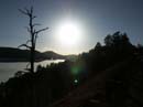
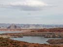
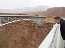
We woke up around 6am, showered and then packed the car. It was still a bit before the restaurant opened, so we drove over to the canyon rim to see things in the morning light. Then we went back to the lodge for breakfast, checked out and then hit the road. We drove south on highway 89 through Kanab, and then headed East towards Page Arizona. Just before page we saw Lake Powell and the Glen Canyon Dam. We drove down to the water so Shannon could dip her toes in. Some people by the boat ramp told us that the water level was some 40% lower than normal, due to lack of rain and increased power demand from the dam.
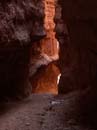
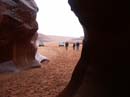
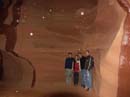
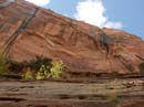
Leaving the dam we drove into Page and checked in with Antelope Canyon Tours. We had a bit of time before the tour left, so we headed up the road and all had Subway sandwiches. Back at the tour company there were quite a number of people waiting to go into the canyon, but after a crash of thunder and rain starting, most of them went back inside for a refund. We decided to go ahead and were driven down to the entrance to the canyon. There was some discussion amongst the driver and the person at the entrance gate about how safe it was to go in (flash floods are a real concern in any canyon, and especially in a slot canyon). They decided that it was ok, though we might have to cut the tour short, so we drove for about 3 miles through a dry wash that ended with a rock wall with a large crack in it, which was the slot canyon. As we drove up there were two other tour company's trucks that were just leaving.
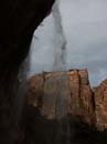
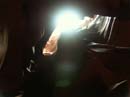
Only one other group, a couple with their young daughter, had come along with us. As we entered the canyon we noticed that it was pretty dry inside. The walls curve around and bend back and forth as they go up, which shelters the floor from most of the rain. Looking up we were treated to some really spectacular colors. With the rain coming through in places from above it was really amazing. The lighting was quite dim, so the only clear pictures ended up being from the one camera with a tripod. On a normal April day we were told that there would have been about 70 people in the canyon with us, in the summer that can go up to as many as 200. That was hard to imagine, since it was a very tight twisty space, as narrow as 3 feet wide in places. The rain had given us the opportunity to have it pretty much to ourselves.
As we got close to the back part of the canyon, there was a larger amount of water starting to come down the walls, and it was starting to puddle on the floor. The guides decided it was time to leave, and we were happy to oblige. Apparently in a really heavy rainstorm flash-floods can reach 80 feet high in the canyon. We didn't want to be anywhere near that! We drove out of the canyon in a light drizzle. We were never in any real danger, but it was very cool to have been in there with waterfalls raining down from above. We were told that it is very rare for people to be in the canyon with any amount of rain coming down.
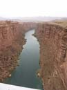
On our way to Zion we decided to take an alternate route, Highway 89A, which runs through northern Arizona. We drove alongside the Vermillion Cliffs which was a huge red rock face that ran for 20 miles or so. Then we crossed over the Colorado River, which was deep in a canyon below us at that point. We were actually at the northern end of the Grand Canyon at that point. We continued along 89A back into Utah and through Kanab. Then, just a bit north of there we headed East into Zion National Park.
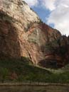
As we entered the park we were treated to some absolutely spectacular rock formations on both sides of the car. It was raining a bit, so we didn't stop, but the views were amazing. We then passed through a several mile tunnel right through one of the mountains, and then down a road with tight switch-backs to reach the valley floor. We continued on through to Springdale on the other side of the park and checked in at our hotel, the Best Western Zion Park Inn.
After checking in we drove back up the road and looked at a few galleries, and Randy bought a rain shell in preparation for a rainy day of hiking on Saturday. We had dinner at the Bit & Spur Saloon then went for a dip in the hotel's hot tub, then headed for bed.
Saturday, April 3
We started a little bit later since we had a good idea that it would be raining. The restaurant at the hotel was closed for a private church group called "EveryMan". We drove down the street to Oscar's Cafe, which served a great egg and pancake breakfast. It was still raining outside, so Randy convinced Rick that he should get a waterproof jacket as well. We got really lucky and the owner of the gear store drove up just a couple of minutes after we did, at 8:30am. With everyone waterproofed we drove up to the visitor's center in the park, parked, and took the tram into the park. Zion switched to using a tram system in 2000, and it seems like it works very well, there are no more traffic jams inside the park, and it's much easier to get from one area to another.
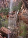
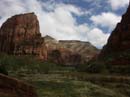
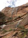
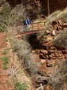
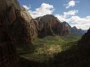
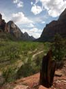
We took the tram all the way to the end, where we did a 2 mile round-trip hike to the Temple of Sinawava. The trail wound through a canyon along the bank of a small river. It was still raining, which was kind of a drag, but it was causing waterfalls to form all over the place. Shannon had been in the park many times, but had never seen the waterfalls before, which was pretty cool. Walking back to the tram we could see some blue sky trying to peek through, which energized us for our next hike, Angel's Landing.
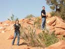
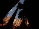
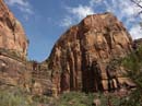
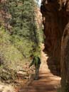
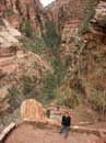
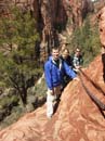
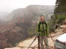
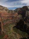
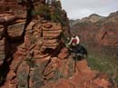
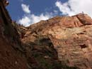
We took the tram back to "The Grotto" and began our trek into the sky. The trail to Angel's Landing is about 5.5 miles round trip, with about 1500 feet of elevation gain. Much of the elevation gain is on narrow switch-backs cut into the hillside. As we ascended the sky cleared and the sun started to shine. It made the whole valley light up and made for a spectacular sight. Half-way up the trail we went through "The Refrigerator", a narrow canyon which is usually much cooler than the surrounding area. Then we went up "Walter's Wiggles", which was sort of like Lombard Street in San Francisco, except that it was sized for pedestrians. Over the next ridge we could look out and see where we were going next: across a very narrow ridge and up a very steep mountain. The trail had thick chains held down with steel posts driven into the rock. Randy kept looking around like a kid in a candy store and marveling at the scenery, this hike was the longest he had ever done, with way more elevation gain, and he was really enjoying it. (Shannon and Chris thought this bodes well for future hiking trips!)
As we started across the ridge, we could see that the weather was changing once again, and dark clouds were moving our way. Right as we reached the top we could see sheets of rain that were just about on top of us. We put our rain gear back on and headed back down the trail as the rain started. The wind picked up, the gusts must have been 50 to 60 miles per hour! We all hung onto the chains as we made our way back down. About as we reached the end of the ridge the rain let up and the sun came back out, making all of the wet rock glisten in the sunlight. What a wild combination of weather!
We took a short rest to eat some snacks and have some water, then continued back down the trail. It went much faster on the way down, and Rick and Randy had fun 'wobbling' along in places. We joked and talked as we made our way down, all giddy from the experience.
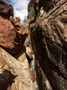
Back on the valley floor we took a trail that led to the Emerald Pools, about a 1.5 mile hike. The trail hugged the wall of the valley, then cut into a canyon where we could see some waterfalls cascading down the walls. We hiked to the middle and lower pools (through a very muddy section at one point) then down a gently descending trail to the Zion Lodge. We were all quite tired from the 9 miles of hiking we had done during the day, with over 2000 feet of elevation. We decided to go to Shannon's favorite smoothie shop just outside the park for fruit smoothies which were just the reward we needed for all of our hard work.
Back at the hotel we showered and headed over the the SwitchBack restaurant where we had a nice dinner and some drinks. After looking through all of our pictures in the room and a quick dip in the hot tub, we were all very ready for sleep.
Sunday, April 4
When the alarm went off at 4:20am it was tough to get up, but we had a 9am flight to catch in Vegas. We packed up the car and were on the road by 5am. There weren't many other cars on the road so we made very fast time back to Vegas. We dropped off Chris and Shannon at Southwest, thanking them for an awesome time on the trip. Then we returned the rental car and headed to our gate with American. Security was a mob scene, though it only took 25 minutes to get through. One of these days they'll figure out how to do security properly... The flight back was short and uneventful, and even nicer since we were upgraded at the last minute.
What an awesome trip it had been! We traveled 897 miles during the course of 4 full days. Chris and Shannon were great traveling companions, giggling and laughing with us the whole time, they are almost as silly as we are! We spent some time talking about future hikes (who knew Randy would be getting excited about hikes?). Glacier National Park and Banff seem like a good possibility for next summer... we'll see!
Equipment
For this trip we used a pair of new Minolta DiMAGE A2 cameras and 2GB Lexar memory cards that we got about a month ago. They turned out to be light enough to carry all day, small enough to fit in the pocket of a rain jacket and produced very high quality 8 megapixel images. About 80% of the images on this page are un-cropped and un-retouched.
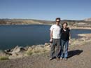
Gunlock Dam


Dust cloud on the horizon

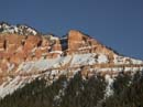
Snow on the mountain!

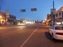
Panguitch at 7pm
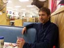
Dinner at the Truck Stop
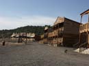
Wild West Town Hotel
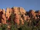
Red Canyon
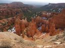
Bryce Canyon

Navajo Canyon


Storm on the horizon


Yvonka!


Bryce at Dawn
Lake Powell

Glen Canyon Dam

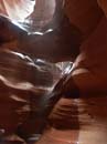
It's raining in here!


Antelope Canyon
Crossing the Colorado

Vermillion Cliffs


Path carved into the cliff
We're headed up there!

Switchbacks

Halfway to the top

Hi!!!

Hold on!


That's heavy rain
right behind Rick!
Catching some rays


Heading to the
Emerald Pools


They're ready for
Fear Factor!